

At the Heart of Society
Construction of 18 DP, Cement Concrete Road from Royal Park Circle to Green City Road in AMC Area,Ambarnath East.
Civikor · Roads · page content
18 m + 12 m DP legs · Ambarnath
/sadashiv-puram-road/
Ambarnath Municipal Council
~672 words
Sadashiv Puram sits between the Central Railway line and Ambarnath's inner road network, reached until now by part-width lanes that stop short of the Development Plan reservation. Civikor surveyed and designed a two-leg DP road — an 18 m north–south link and a 12 m east–west connector — that gives the pocket a direct, full-width route out to B Cabin Road.
| Project | Construction of DP cement concrete road from Sadashiv Puram to B Cabin Road (Aqua Marine stretch), AMC Area |
|---|---|
| Client | Ambarnath Municipal Council |
| Location | Sadashiv Puram, Ambarnath, Dist. Thane, Maharashtra |
| Configuration | Two DP legs — 18.00 m wide north–south link and 12.00 m wide east–west connector |
| Corridor length | [CONFIRM — see note] |
| Pavement type | Rigid — cement concrete |
| Civikor's role | Survey, DP alignment marking, design drawings and project management consultancy |
| Status | Ongoing |
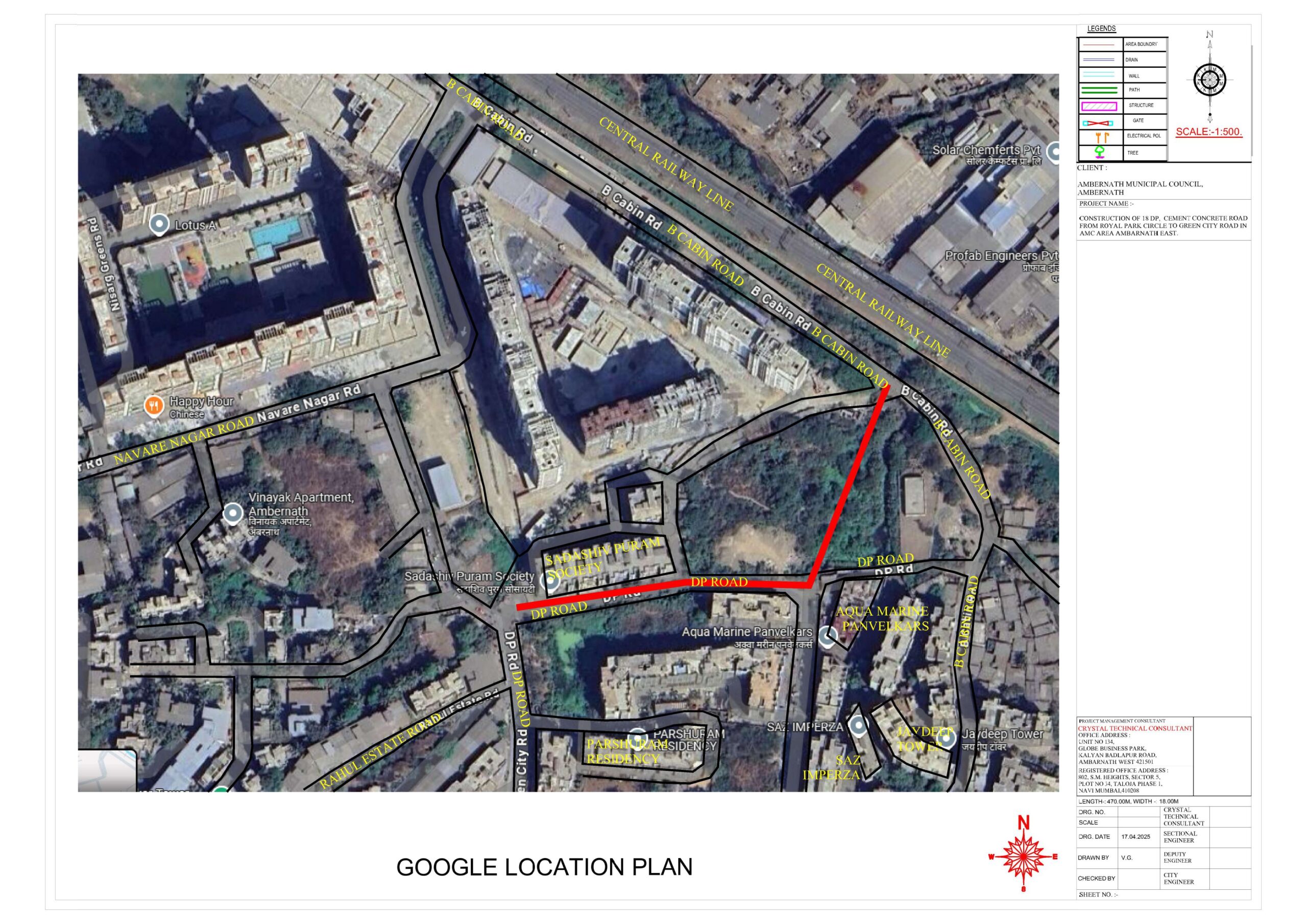
The neighbourhood around Sadashiv Puram Society has densified steadily — Parshuram Residency, Aqua Marine, Patwelkars, Sai Imperza and Javdeep Tower now sit along a corridor whose Development Plan road had never been built to width. Traffic from all of them funnels onto B Cabin Road through constrained lanes, with the Central Railway line closing off any alternative to the south-east.
Ambarnath Municipal Council needed the reserved DP width established on the ground, and a road built to carry the pocket's growing load rather than merely resurface the existing track.
The corridor is not a single straight link. It steps: an 18 m leg serving the denser residential frontage, meeting a 12 m leg that carries the connection west to the existing arterial. Designing them as one project — rather than two separate works — keeps the junction geometry, drainage fall and pavement levels continuous, which is where stitched-together municipal roads usually fail.
The Central Railway line and B Cabin Road fix the corridor's eastern edge absolutely; the gaothan and reserved plots fix the west. There is no alignment flexibility here, so the design effort went into fitting the full DP width and its drainage inside a corridor that cannot be widened later.
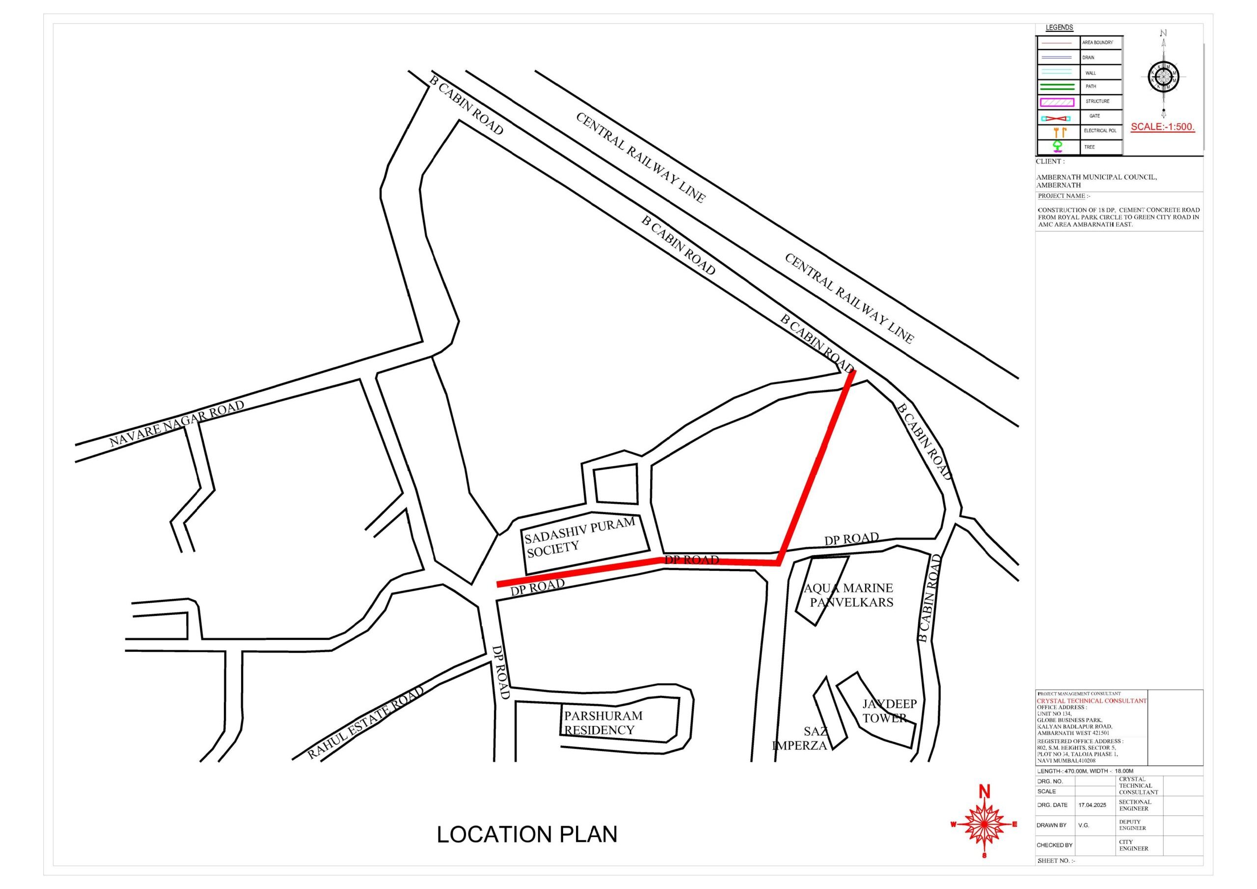
Every plan names the societies and buildings it passes. For a municipal council reviewing an alignment through occupied land, a drawing that says "Aqua Marine" and "Javdeep Tower" is checked and approved faster than one that only gives coordinates.
<!-- ===== CIVIKOR PROJECT CONTENT BLOCK :: /sadashiv-puram-road/ ===== -->
<!-- IMPORTANT: the description currently live on this page belongs to the Royal Park Road
     project. See the audit note at the foot of this file before publishing. -->

<section class="ck-block">
  <h2>Sadashiv Puram to B Cabin Road — opening up a landlocked residential pocket</h2>
  <p class="ck-lead">Sadashiv Puram sits between the Central Railway line and Ambarnath's inner road network, reached until now by part-width lanes that stop short of the Development Plan reservation. Civikor surveyed and designed a two-leg DP road — an 18 m north–south link and a 12 m east–west connector — that gives the pocket a direct, full-width route out to B Cabin Road.</p>
</section>

<section class="ck-block">
  <h3>At a glance</h3>
  <table class="ck-table">
    <tbody>
      <tr><th scope="row">Project</th><td>Construction of DP cement concrete road from Sadashiv Puram to B Cabin Road (Aqua Marine stretch), AMC Area</td></tr>
      <tr><th scope="row">Client</th><td>Ambarnath Municipal Council</td></tr>
      <tr><th scope="row">Location</th><td>Sadashiv Puram, Ambarnath, Dist. Thane, Maharashtra</td></tr>
      <tr><th scope="row">Configuration</th><td>Two DP legs — 18.00 m wide north–south link and 12.00 m wide east–west connector</td></tr>
      <tr><th scope="row">Corridor length</th><td><span class="ck-todo">[CONFIRM — see note]</span></td></tr>
      <tr><th scope="row">Pavement type</th><td>Rigid — cement concrete</td></tr>
      <tr><th scope="row">Civikor's role</th><td>Survey, DP alignment marking, design drawings and project management consultancy</td></tr>
      <tr><th scope="row">Status</th><td>Ongoing</td></tr>
    </tbody>
  </table>
</section>

<section class="ck-block">
  <h3>The brief</h3>
  <p>The neighbourhood around Sadashiv Puram Society has densified steadily — Parshuram Residency, Aqua Marine, Patwelkars, Sai Imperza and Javdeep Tower now sit along a corridor whose Development Plan road had never been built to width. Traffic from all of them funnels onto B Cabin Road through constrained lanes, with the Central Railway line closing off any alternative to the south-east.</p>
  <p>Ambarnath Municipal Council needed the reserved DP width established on the ground, and a road built to carry the pocket's growing load rather than merely resurface the existing track.</p>
</section>

<section class="ck-block">
  <h3>Scope of work</h3>
  <ul class="ck-list">
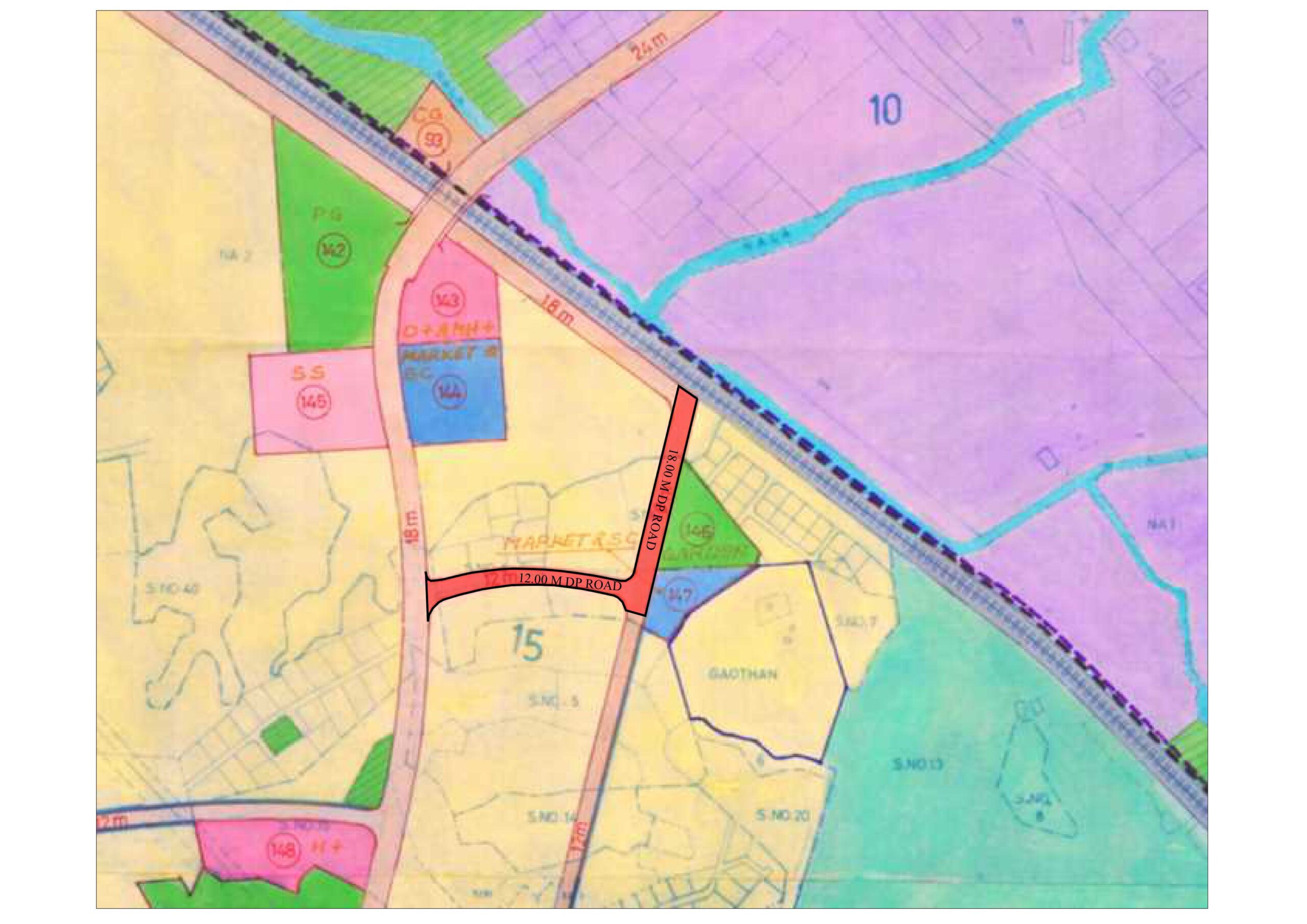
    <li><strong>DP plan interpretation</strong> — the sanctioned Development Plan sheet read against the ground to fix both legs of the alignment: an 18.00 m road running north from the internal junction, and a 12.00 m road running west toward the existing 18 m arterial.</li>
    <li><strong>Location plan at 1:500</strong> setting the alignment against Sadashiv Puram Society, Parshuram Residency, Aqua Marine, Patwelkars, Sai Imperza, Javdeep Tower, Navare Nagar Road, Rahul Estate Road and B Cabin Road.</li>
    <li><strong>Google location plan</strong> for satellite verification of the corridor and its junctions.</li>
    <li><strong>Rigid pavement and drainage design</strong> to AMC's standard concrete road section.</li>
    <li><strong>Project management consultancy</strong> through execution.</li>
  </ul>
</section>

<section class="ck-block">
  <h3>How we approached it</h3>
  <h4>Two widths, one continuous route</h4>
  <p>The corridor is not a single straight link. It steps: an 18 m leg serving the denser residential frontage, meeting a 12 m leg that carries the connection west to the existing arterial. Designing them as one project — rather than two separate works — keeps the junction geometry, drainage fall and pavement levels continuous, which is where stitched-together municipal roads usually fail.</p>

  <h4>Working against a hard boundary</h4>
  <p>The Central Railway line and B Cabin Road fix the corridor's eastern edge absolutely; the gaothan and reserved plots fix the west. There is no alignment flexibility here, so the design effort went into fitting the full DP width and its drainage inside a corridor that cannot be widened later.</p>

  <h4>Landmark-referenced approvals</h4>
  <p>Every plan names the societies and buildings it passes. For a municipal council reviewing an alignment through occupied land, a drawing that says "Aqua Marine" and "Javdeep Tower" is checked and approved faster than one that only gives coordinates.</p>
</section>

<section class="ck-block">
  <h3>Why it matters</h3>
  <ul class="ck-list ck-list--tick">
    <li><strong>A landlocked pocket gets a real exit.</strong> Residents reach B Cabin Road and the wider network on a full-width surfaced road instead of a constrained internal lane.</li>
    <li><strong>DP width secured before it is lost.</strong> Building the reservation now protects it from the encroachment that has already narrowed comparable corridors in Ambarnath.</li>
    <li><strong>Emergency access.</strong> An 18 m carriageway means ambulances and fire tenders can reach the interior of the pocket — something the previous section could not guarantee.</li>
    <li><strong>Rigid pavement</strong> suited to monsoon conditions and to a corridor where future resurfacing closures would be difficult to divert around.</li>
  </ul>
</section>

<section class="ck-block">
  <h3>Drawing set</h3>
  <ol class="ck-list ck-list--num">
    <li><strong>Location plan (1:500)</strong> — Sadashiv Puram to Aqua Marine, alignment against named societies and roads.</li>
    <li><strong>Google location plan</strong> — corridor on satellite imagery.</li>
    <li><strong>DP plan</strong> — Sadashiv Puram to B Cabin Road, showing the 18.00 m and 12.00 m DP road legs over the sanctioned Development Plan sheet.</li>
  </ol>
</section>

<!--
  ================= AUDIT NOTE — REMOVE BEFORE PUBLISHING =================
  1. The description currently live on /sadashiv-puram-road/ reads "Construction of 18 DP,
     Cement Concrete Road from Royal Park Circle to Green City Road" — that is the Royal Park
     Road project. It must be replaced.
  2. The error is inherited, not a website mistake: the title block on
     "LOCATION PLAN - SADASHIV PURAM TO AQUA MARIN.pdf" itself carries Royal Park Road's
     name of work and its LENGTH = 470.00M / WIDTH = 18.00M. The drawing body is
     unmistakably Sadashiv Puram. The CAD title block was copied and not updated.
  3. Because of (2), the true corridor length for Sadashiv Puram is NOT established anywhere
     in the shared files. Get it from Crystal Technical Consultant / AMC before the
     "Corridor length" row goes live, and correct the source drawing at the same time.
  ========================================================================
-->

<!-- ===== END CONTENT BLOCK ===== -->Let’s discuss how we can help bring your infrastructure vision to life.

PMC, EPC and construction technology for public and private infrastructure across India.