

At the Heart of Society
Construction of 18 DP, Cement Concrete Road from Royal Park Circle to Green City Road in AMC Area, Ambarnath East.
Civikor · Roads · page content
470 m · 18 m DP road · Ambarnath East
/royal-park-road/
Ambarnath Municipal Council
~742 words
Ambarnath East's Royal Park pocket had grown faster than the road serving it. Civikor was appointed to take a 18 m Development Plan road from survey to construction-ready drawings, turning a congested residential link into a full-width concrete corridor with drainage, footpaths and utility crossings designed in from day one.
| Project | Construction of 18 m DP cement concrete road from Royal Park Circle to Green City Road |
|---|---|
| Client | Ambarnath Municipal Council |
| Location | Royal Park Circle to Green City Road, Ambarnath East, Dist. Thane, Maharashtra |
| Corridor length | 470.00 m |
| DP road width | 18.00 m |
| Pavement type | Rigid — cement concrete |
| Civikor's role | Survey, Development Plan alignment marking, design drawings and project management consultancy |
| Drawing set date | 17 April 2025 |
| Status | Ongoing |
Royal Park Road is the spine that links the Royal Park residential cluster to Green City Internal Road, and onward to Katai Pipe Line Road. On paper it is an 18 m Development Plan reservation. On the ground it had been reduced to a part-width carriageway boxed in by compound walls, gates, poles and mature trees — the usual result when private development outpaces the DP.
Ambarnath Municipal Council needed the full reserved width recovered and built as a rigid pavement, without the project stalling on encroachment disputes or unmapped services. That made the survey, not the concrete, the critical path.
Rather than design to the theoretical 18 m and discover the conflicts on site, the corridor was surveyed in full and every obstruction plotted with a legend the council's engineers could read at a glance — trees, gates, structures, walls, paths, drains and electrical poles each carry their own symbol. The result is a single sheet that answers the question every DP road project runs into: what actually has to move, and where?
The corridor fronts housing societies and a school. The section therefore carries continuous footpath and edge drainage on both sides rather than treating them as optional extras — pedestrian movement and stormwater are engineered as part of the road, not retrofitted after it.
Cross ducts are provided at the design stage so that future water, power and telecom connections can be pulled across the road without cutting a newly laid concrete slab. On a rigid pavement this is the difference between a 30-year asset and a patchwork one.
<!-- ===== CIVIKOR PROJECT CONTENT BLOCK :: /royal-park-road/ ===== -->

<section class="ck-block">
  <h2>Connecting Royal Park to Green City — a 470 m DP road built to last</h2>
  <p class="ck-lead">Ambarnath East's Royal Park pocket had grown faster than the road serving it. Civikor was appointed to take a 18 m Development Plan road from survey to construction-ready drawings, turning a congested residential link into a full-width concrete corridor with drainage, footpaths and utility crossings designed in from day one.</p>
</section>

<section class="ck-block">
  <h3>At a glance</h3>
  <table class="ck-table">
    <tbody>
      <tr><th scope="row">Project</th><td>Construction of 18 m DP cement concrete road from Royal Park Circle to Green City Road</td></tr>
      <tr><th scope="row">Client</th><td>Ambarnath Municipal Council</td></tr>
      <tr><th scope="row">Location</th><td>Royal Park Circle to Green City Road, Ambarnath East, Dist. Thane, Maharashtra</td></tr>
      <tr><th scope="row">Corridor length</th><td>470.00 m</td></tr>
      <tr><th scope="row">DP road width</th><td>18.00 m</td></tr>
      <tr><th scope="row">Pavement type</th><td>Rigid — cement concrete</td></tr>
      <tr><th scope="row">Civikor's role</th><td>Survey, Development Plan alignment marking, design drawings and project management consultancy</td></tr>
      <tr><th scope="row">Drawing set date</th><td>17 April 2025</td></tr>
      <tr><th scope="row">Status</th><td>Ongoing</td></tr>
    </tbody>
  </table>
</section>

<section class="ck-block">
  <h3>The brief</h3>
  <p>Royal Park Road is the spine that links the Royal Park residential cluster to Green City Internal Road, and onward to Katai Pipe Line Road. On paper it is an 18 m Development Plan reservation. On the ground it had been reduced to a part-width carriageway boxed in by compound walls, gates, poles and mature trees — the usual result when private development outpaces the DP.</p>
  <p>Ambarnath Municipal Council needed the full reserved width recovered and built as a rigid pavement, without the project stalling on encroachment disputes or unmapped services. That made the survey, not the concrete, the critical path.</p>
</section>

<section class="ck-block">
  <h3>Scope of work</h3>
  <ul class="ck-list">
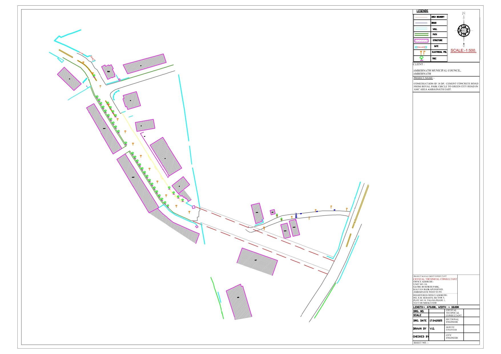
    <li><strong>Topographical survey of the full 470 m corridor</strong> — every existing tree, compound wall, gate, structure, footpath, drain and electrical pole recorded and classified on the survey plan, so the council could see exactly what sat inside the reservation before a single notice was issued.</li>
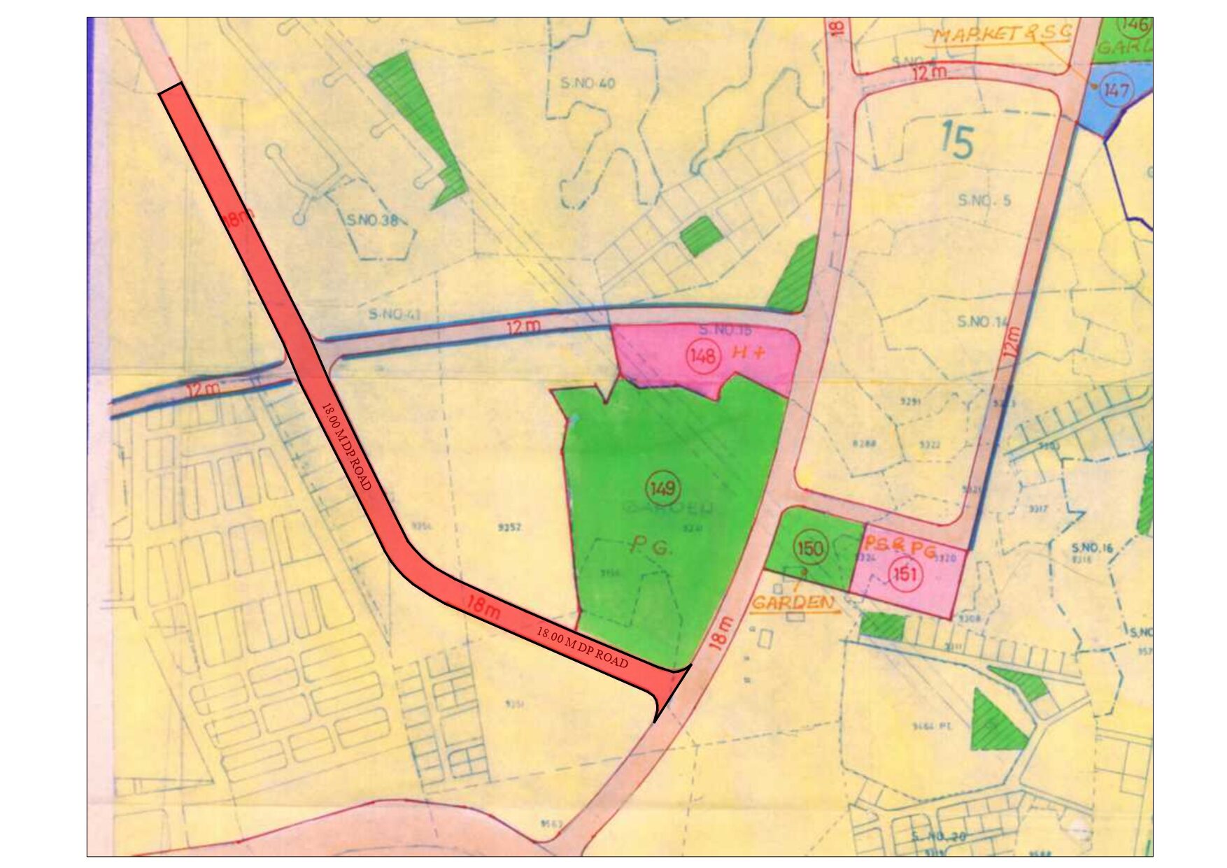
    <li><strong>DP alignment marking</strong> — the 18 m reservation overlaid on the surveyed ground condition, establishing the centre line and the true available width chainage by chainage.</li>
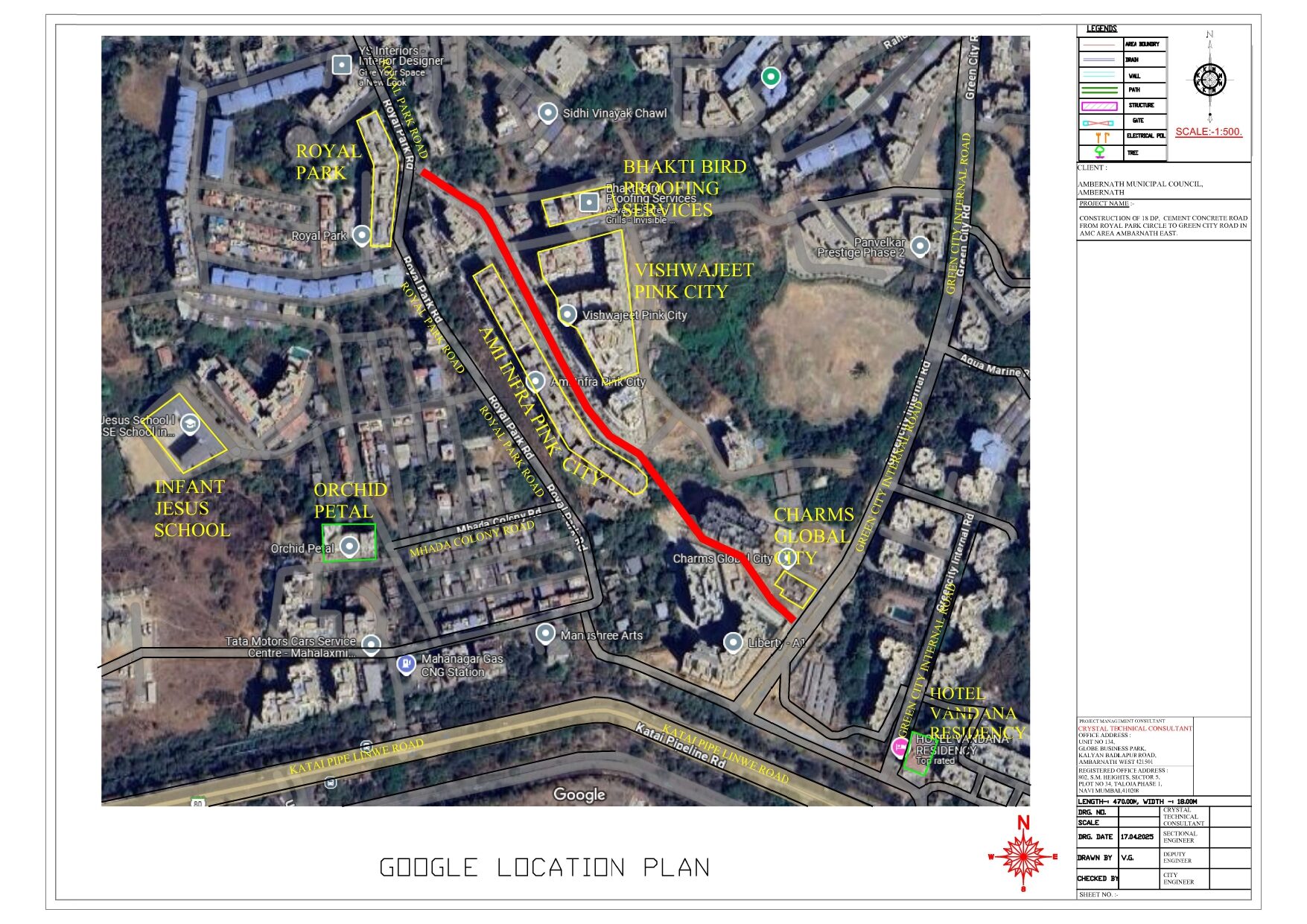
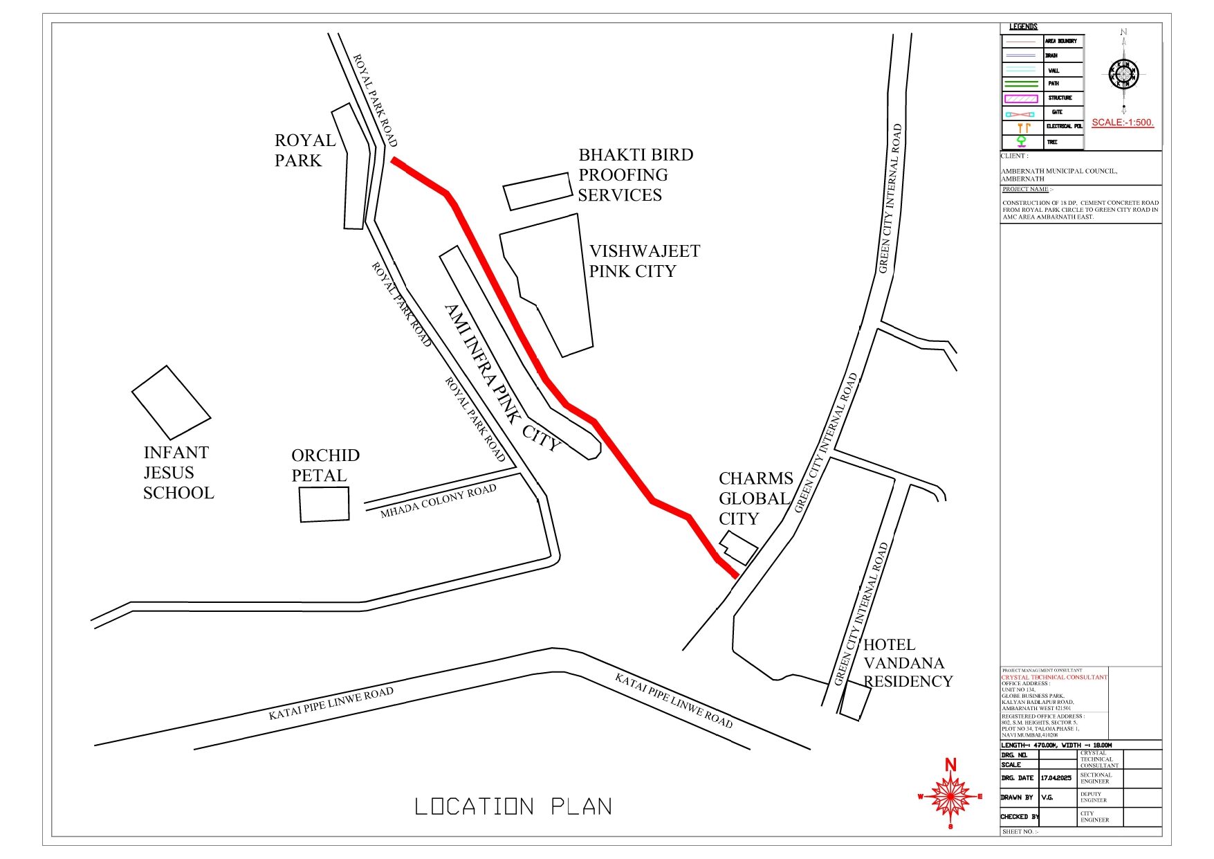
    <li><strong>Location and key plans</strong> — the corridor set in context against Royal Park, Ami Infra Pink City, Vishwajeet Pink City, Charms Global City, Orchid Petal, Infant Jesus School and MHADA Colony Road, so approvals could be granted against recognisable landmarks rather than coordinates alone.</li>
    <li><strong>Design and construction drawings</strong> for the concrete pavement, edge drainage and footpath.</li>
    <li><strong>Project management consultancy</strong> through execution — quality checks, measurement verification and progress reporting to AMC.</li>
  </ul>
</section>

<section class="ck-block">
  <h3>How we approached it</h3>
  <h4>Survey first, design second</h4>
  <p>Rather than design to the theoretical 18 m and discover the conflicts on site, the corridor was surveyed in full and every obstruction plotted with a legend the council's engineers could read at a glance — trees, gates, structures, walls, paths, drains and electrical poles each carry their own symbol. The result is a single sheet that answers the question every DP road project runs into: <em>what actually has to move, and where?</em></p>

  <h4>Designed for a residential street, not a highway</h4>
  <p>The corridor fronts housing societies and a school. The section therefore carries continuous footpath and edge drainage on both sides rather than treating them as optional extras — pedestrian movement and stormwater are engineered as part of the road, not retrofitted after it.</p>

  <h4>Utilities crossed before the pavement is poured</h4>
  <p>Cross ducts are provided at the design stage so that future water, power and telecom connections can be pulled across the road without cutting a newly laid concrete slab. On a rigid pavement this is the difference between a 30-year asset and a patchwork one.</p>
</section>

<section class="ck-block">
  <h3>Why it matters</h3>
  <ul class="ck-list ck-list--tick">
    <li><strong>Full DP width recovered.</strong> The reservation is built out to its planned 18 m, protecting the corridor's capacity for the next generation of development rather than locking in today's constraint.</li>
    <li><strong>A 30-year pavement.</strong> Rigid cement concrete construction suits Ambarnath's monsoon loading and heavy local traffic far better than a bituminous surface that needs resealing every few seasons.</li>
    <li><strong>Fewer surprises, fewer claims.</strong> A complete pre-construction survey record gives the council defensible documentation for encroachment, tree and utility decisions — the three things that most often delay municipal road work.</li>
    <li><strong>Safe pedestrian movement</strong> past a school and dense residential frontage, with drainage that keeps the carriageway serviceable through the rains.</li>
  </ul>
</section>

<section class="ck-block">
  <h3>Drawing set</h3>
  <ol class="ck-list ck-list--num">
    <li><strong>Google location plan</strong> — corridor mapped on satellite imagery for orientation and approvals.</li>
    <li><strong>Location plan (1:500)</strong> — alignment against named landmarks and adjoining roads.</li>
    <li><strong>DP marking plan</strong> — the 18 m Development Plan reservation over the sanctioned DP sheet.</li>
    <li><strong>Survey plan (1:500)</strong> — existing trees, walls, gates, structures, drains, paths and electrical poles across the full corridor.</li>
  </ol>
</section>

<!-- ===== END CONTENT BLOCK ===== -->Let’s discuss how we can help bring your infrastructure vision to life.

PMC, EPC and construction technology for public and private infrastructure across India.